Druk Path Trek
This 5-6 days “druk path trek” is fairly easy and magnificent as the route passes through beautiful scenes, good views of snow-capped Himalayan peaks, a monastery high up in the mountain and a visit to a Dzong. At some point, the trail is through beautiful forest of Fir, Blue pine and dwarf Rhododendrons. Part of the route follows the original mule track that linked Thimphu and Paro valleys, and eventually connected Bhutan to the Indian border.
Grade : Moderate – Demanding
Time : 06 Days
Distance : 30miles/48kms.
Best Season : Between March-June and September-November.
Paro to Jele Dzong
- Time : 4-5hrs.
- Ascent : 1,090m.
- Altitude : 2450m. to 3436m.
The track starts from Ta Dzong (National Museum). The first day could be quite strenuous as the track climbs non-stop for over 1,065 m. Following the gravel road passing few farmhouses and apple orchards, the trail passes through Pine forest and after firm climbing, there will be nice views of Paro valley, and Jele Dzong above the ridge. Continue walking through the trail and just before reaching a small pass, the campsite is a little way down from the pass.
Jele Dzong to Tshokam
- Time : 4-5hrs.
- Ascent : 310m.
- Descent : 50m.
- Altitude : 3436m. to 3962m.
After climbing steeply for a while the slop evens a bit and the ascent is more gradual. The trail provides beautiful views of Paro valley and Dagala range (another trekking area). The route passes through forest that was damaged by Bark Beetles in 1980’s. The campsite “Tshokam” is 4 hrs away from here.
Tshokam to Jimilangtsho
- Time : 6-7hrs.
- Ascent : 213m.
- Descent : 295m.
- Altitude : 3962m. to 3880m.
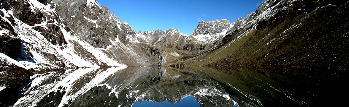
The track crosses two small pass and provides stunning views of snow-capped Mt. Jomolhari to the north and a number of monasteries of Paro down below. On the reverse side there is a view of Jimilang Tsho. The route comes across many small lakes with promising campsites, but the best is near Jimilang Tsho. The lake is known for its enormous size Trout. We can organize catch and release fishing permit at your service.
Jimilang Tsho to Simkotra Tsho
- Time : 3-4hrs.
- Ascent : 820m.
- Descent : 400m.
- Altitude : 3880m. to 4090m.
The route takes around the lake to its far end. There is some steep climbing through the bushes and dwarf Rhododendron allowing good views later. From here you can see a lake below, a pleasant campsite, which may be occupied by Yak herders. The route comes through many small lakes including male and female. The campsite is close to Simkotra Tsho which has some stone ruins nearby, making the camp gorgeous.
Simkotra Tsho to Phajoding
- Time : 5hrs.
- Ascent : 230m.
- Descent : 405m.
- Altitude : 4090m. to 3690m.
There are seven minor climbs to small passes before you finally look down to Phajoding Monastery. Stunning Mt. Gangkar Puensum is visible, and if whether permits, the rest of the Bhutan Himalaya can be seen. After crossing the final small pass, the campsite is reached. Camping at Phajoding is absolutely a worthwhile.
Phajoding to Motithang
- Time : 2-3hrs.
- Ascent : 0m.
- Descent : 872m.
- Altitude : 3690m. to 2818m.
There three possible trails to Thimphu from Phajoding, and the most favored is, the steep route wooded area of Blue pine that exists near the Queen’s compound. From here, drive down to Thimphu, passing the mini zoo, where some Takins can be seen.